Terroir and characteristics of the wines of Alsace
The hillsides of Alsace
The best terroirs in Alsace are located on the ridges by the foothills of the Voges, between two geological faults. Here, the bedrock is a mosaic of cracks and disruptions in many directions. On top of the bedrock, soils of varying origin form a thin layer that has either has been formed on site, as alluvium or moved by gravity from higher elevations.
The heading photograph shows how the "fingers" connecting the granitic mountain range and the plain are shaped. The picture is taken from north to south from above Kientzheim, showing the village Ammerschwihr. In fact, the photo is taken from th edge of Grand Cru Furstentum, showing Grand Cru Kaefferkopf.
The upper parts of the hillsides are granitic, normally followed by Bundsandstein, Muschelkalk and marl of various origin. Here and there, for example on Grand Crus Altenberg de Bergheim and Florimont (Ingersheim) oolitic Jurassic limestone dominates, but this is quite rare.
The plain on the picture consists of alluvium deposited by the river Weiss during Quartenary.
The map below shows the most reputed section of the heart of Alsace. On the map, Crand Crus of similar geological character are shown in a certain color.
On bedrock from Triassic and Jurassic, one can separate the Grands Crus into three classes; limestone, an intermediate group and terroirs low in lime. The rule of thumb is that the higher the lime content, the more acidity is brought to the wine. If the acid content is high, the grapes may be harvested quite late which gives a good chance of making a wine that combines body, complexity and storage potential.
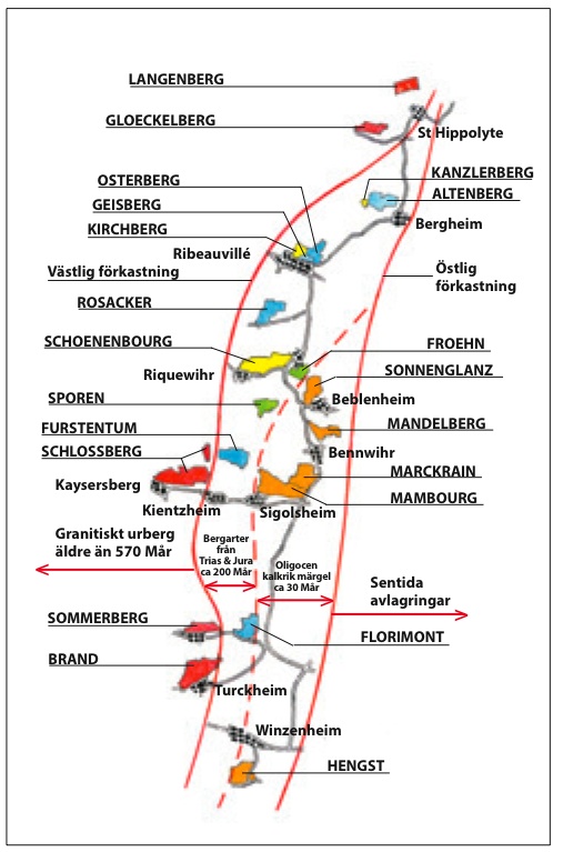
The map is taken from the magazine Munskänken 06/2004. Created by Ulf Jansson (artwork) and Per Warfvinge (idea). Legend: Östlig förkastning = Eastern fault, Västlig förkastning = Western fault,
Limestone gives acidity
Muschelkalk and other forms of carbonates contributes elegans, focus och citrus aromas (fr. Agrumes). Many superior terroirs are calcareous, e.g. Rosacker (Hunawihr) including the famed Clos St Hune, Altenberg de Bergheim, Zinnkoepflé (Westhalten) and Furstentum (Kientzheim), as well as the northen-most of Grands Crus, Steinklotz (Marlenheim)
Marl on warm soils give power
The intermediate group includes terroirs with marl and calcareous sandstones. Marl is very common in Alsace and gives wines with a certain brutal roughness. Personal favourites among marly terroirs with warm soils include Schoenenbourg (Riquewihr), Osterberg (Ribeauvillé), Pfersigberg (Eguisheim) and the Lieu-dit Muhlforst (Hunawihr).
Oligocene marly conglemorates are risky
The terroirs on limestone rich marl from Oligocene include Grand Crus Sonnenglanz (Beblenheim), Mandelberg (Mittelwihr) and Mambourg (Sigolsheim). They have the potential to give superiour wines with acidity and body. However the conglemorates tend to weather to heavy, cold soils that require perfect weather to ensure a good ripening process. While Mambourg, perfectly south-facing, can provide the sunlight that allows perfect maturation almost any year, other Oligocene terroirs will give Rieslings with rough edges in less than perfect vintages. Furthermore, Pinot Gris is very likely to suffer from humidity that will inevitably be struck by a fair share of grey rot.
Lack of lime
Terroirs low in lime, such as Froehn (Zellenberg) and Sporen (Riquewihr) are not suitable for Riesling because the levels of acidity will be to low. Instead, these are soils for Gewurztraminer.
Granite gives born to real charmers
Several Grand Crus rest on the garnitic bedrock, just west of the western fault. Granit is hard and will only slowly be decomposed to a sandy soil. Drainage is very good, and the soils will heat up early on clear autumn days. However, the lack of water causes the wines from warm granite terroirs such as Brand (Turckheim) and Schlossberg (Kientzheim/Kayersberg) to be best in intermediate years. If the microclimate is cooler such as on Sommerberg (Niedermorschwihr) and Wineck-Schlossberg (Katzenthal) one should look for the warm vintages to find the best wines.
A few more things
There are a few interesting Grands Crus on unique geology. One is the legendary Rangen de Thann, situated on the dramatic southern slope of a volcano. There are two main producers on Rangen, Zind-Humbrecht and Schoffit, creating arguably the most magnificent wines of region. In addition, two minor producers in Eguisheim (Bruno Hertz and Paul Zinck) market Rangen. An other unique terroir is Kastelberg (Andlau) where Kreydenweiss, Guy Wach and Gresser make outstanding wines with remarkable complexity.
Some terroirs hold inclusions of special minerals. For example, Schoenenbourg has some gypsym, Froehn some iron compounds and Kanzlerberg both gypsum and fluorite.
As obvious from the above, the deep soils of Plaine d´Alsace are to wet, flat and to low in limestone to yield anything beyond bulk wines.
About Riesling
To sum up, great Riesling grows either on complex, warm soils rich in limestone (e.g. Schoenenbourg) or calcareous, cold soils with an extremely favourable microclimate (e.g. Rosacker, Furstentum and Hengst). On difficult cold soils, it is sometimes necessary to allow some malo-lactic fermentation to achieve a reasonable balance in lesser years.